


Cartes IGN
Description of Cartes IGN
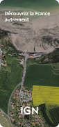
IGN Maps is a mapping application that provides users with access to detailed geographic information across France. This app is designed for both Android users and those using mobile devices and tablets. IGN Maps offers a range of practical tools that assist in navigation while ensuring user privacy, including route calculation, route tracing, landmark creation, and position sharing with contacts.
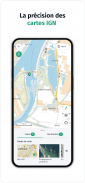
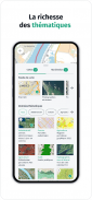
The application features IGN's high-quality base maps, which include both IGN plans and topographic maps. These maps are complemented by a rich array of thematic geographic data made available through the IGN and its partners. Users can explore various themes such as administrative boundaries, land use, agriculture, forestry, tourism, and transport. Such diverse data helps users to gain a better understanding of the French landscape and its features.
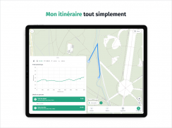
A significant aspect of IGN Maps is its user-friendly interface, which allows individuals to easily navigate and explore the app’s functionalities. Users can calculate routes to their desired destinations with ease, using the straightforward route calculation feature. This tool allows for customized journey planning, ensuring that users can find the most efficient paths to their locations.
Another important feature is the ability to trace routes. This function enables users to draw their paths on the map, helping them to visualize and plan their journeys. Whether it’s for hiking, cycling, or simply exploring new areas, this capability can enhance the overall experience of outdoor activities.
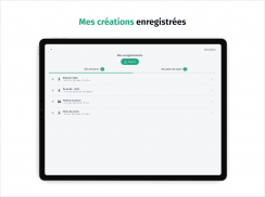
Creating and saving landmarks is another useful feature within IGN Maps. Users can mark specific points of interest, allowing them to easily revisit these locations later. This feature is particularly beneficial for those who enjoy exploring the outdoors, as it helps organize favorite spots and facilitates easier navigation in the future.
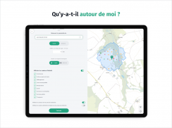
The app also allows users to display their current position on the map. This real-time tracking feature is essential for navigating unfamiliar areas or for outdoor activities such as hiking or biking. Users can also share their location with loved ones, ensuring safety and ease of coordination during outings.
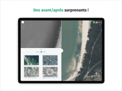
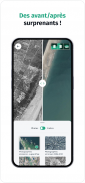
IGN Maps offers a unique perspective on the evolution of French landscapes over time. Users can compare historical aerial photographs and maps to observe changes in the environment due to climate change. This comparison feature can be particularly enlightening for those interested in geography and environmental studies, as it provides visual evidence of human impact on the landscape.
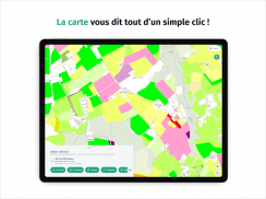
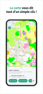
The app's interactive map function provides additional insights about various geographic features. By clicking on specific areas, users can access more detailed information regarding buildings, land use, and types of cultivation. This tool enhances the educational aspect of the application, making it suitable for both casual users and those seeking deeper knowledge about the French territory.
Accessibility is a core component of IGN Maps. The application is available for download on Android devices, making it convenient for users to access essential mapping tools on-the-go. The combination of ease of use and thorough geographic data makes IGN Maps a valuable resource for anyone looking to explore France.
Users benefit from the wealth of thematic geographic data offered by the application. This data is not only informative but can also aid in planning various activities, from outdoor adventures to educational pursuits. The thematic layers available allow users to tailor their maps to fit their specific interests, whether they are focusing on tourism, agriculture, or forestry.
The app also emphasizes user privacy by providing navigation tools without tracking users' movements. This approach ensures that individuals can explore their surroundings without the concern of being monitored, which is increasingly important in today's digital age.
With its diverse features and user-friendly design, IGN Maps serves as a comprehensive tool for navigating and understanding the French landscape. The combination of detailed maps, thematic data, and the ability to create and save personalized routes and landmarks makes it a versatile application for various users.
In catering to a wide range of geographic interests, IGN Maps stands out as a practical application for anyone looking to explore France's rich and diverse landscapes. The ability to access historical data and compare it with current maps adds an educational layer that can enrich users' experiences while exploring the territory.
For those seeking to enhance their navigation and exploration of France, downloading IGN Maps offers a straightforward solution that combines practicality with a wealth of information. The app's features are designed to assist users in their journeys, whether they are planning a hike, exploring new towns, or simply wishing to learn more about the geography of the area.
Incorporating both modern mapping technology and historical insights, IGN Maps is well-equipped to meet the needs of a broad audience interested in discovering the intricacies of the French territory.
Cartes IGN - Version 3.2.9
(12-03-2025)Cartes IGN - APK Information
APK Version: 3.2.9Package: fr.ign.geoportailLatest Version of Cartes IGN
Other versions


Apps in the same category

You may also like...


